Introduction
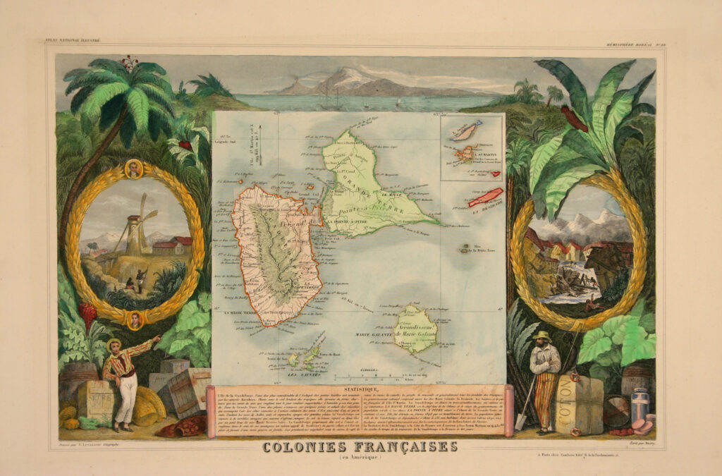
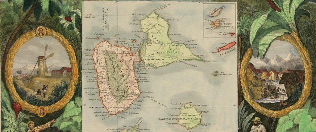
Cartographer Victor Levasseur’s Colonies Françaises (en Amérique) from Atlas National Illustrè, reveals more than a cartographic understanding of the island of Guadeloupe (Figure 1). It divulges the power relations inherent to the French Lower West Indies amidst a swiftly changing social and political climate. Created eight years after the abolition of slavery in France and its colonies, this map creates a carefully orchestrated narrative about the perceived collapse of colonial control, economic production, and social hierarchy. Levasseur’s central map is surrounded by two cartouches, an expansive landscape, and an inscription explaining the population, climate, and current events on the island. The cartouche on the left depicts a seemingly picturesque representation of agricultural labor, featuring portraits of Guillaume Lethiére, a prominent Guadeloupean mixed-race painter, and Coupenon, likely of the plantation-owning class. The cartouche on the right illustrates the horrifying moments during the 1843 earthquake. By focusing on the hierarchical relationship between these different components of the picture, this essay investigates how the composition reinforces colonial authority while simultaneously documenting the crucial aspects of the transformation of society in Guadeloupe.
Building on this complexity, examining the map’s embellishments and aesthetics reveals deeper historical significance about contemporary perceptions and power relations in the post-abolition Lower West Indies, particularly in under-studied French colonies. This analysis will develop and apply Krista Thompson’s sidelong glance to this representation, investigating the visible and invisible aspects of its imagery.7 Thompson’s approach pushes us to investigate how this representation works to reinforce colonial authority while simultaneously documenting the crucial aspects of transformation in society in Guadeloupe. The intentional inclusion and positioning of certain figures, events, and symbols provide crucial insight into how French colonial authorities sought to represent their continuing influence over Guadeloupe during this period of significant social and economic change.
A Krista Thompson Sidelong Glance
While Krista Thompson’s sidelong glance provides a method of viewing African diasporic representations, this 1856 map of Guadeloupe internalizes this dynamic within its own composition, developing the tension between visible and invisible elements as an integral component of its visual narrative. Viewing this entire work with Thompson’s sidelong glance provides a crucial framework for understanding how this map operates at multiple complex levels. By contemplating both the visible and invisible elements that relate to the creation and significance of this work, we uncover how the map simultaneously documents and obscures colonial realities in post-abolition Guadeloupe.
An important demonstration of this concept is the tension that exists between architectural elements surrounding the map and within the cartouches. The windmill in the left cartouche and plantation buildings exist as a stark contrast to the Guadeloupean landscape which engulfs these representations. Serving as a reminder of colonial power, this juxtaposition between the plantation buildings and the Guadeloupean landscape reveals the invisible struggle between colonial imposition and the indigenous environment. Levasseur’s inclusion and positioning of the windmill in a dominant position to the figures in the left cartouche serves as a visible symbol of colonial control. Meanwhile, the windmill’s positioning and inclusion in the work invisibly suggest the continued enforcement of European agricultural practices and colonial power dynamics in a post-abolition society.
The visible, yet obscured, presence of Black figures throughout the map’s embellishments points to invisible power structures that remain in Guadeloupe’s post-abolition society. The positioning of these figures – whether laboring in the fields in the left cartouche or shadowed behind cotton in the landscape – reveals the continuation of colonial hierarchies despite the abolition of slavery. Although there is no direct depiction of slavery, the invisible harsh reality of post-emancipation labor conditions is uncovered through studying this map, regardless of its obstruction by the visible aesthetics of productivity and wealth.
Historical Context
To understand this representation of Guadeloupe and its complexities, some key events relating to Guadeloupe’s turbulent history must be discussed. The island of Guadeloupe in the late eighteenth and early nineteenth century was in constant change, particularly viewed through the frequent shift in colonial control and progression of the abolition movement at the time. Up to the 1750s, Guadeloupe was set up similar to other French colonies in the West Indies, primarily made up of sugar plantations.During the Seven Years War between 1759 and 1763, British forces invaded Guadeloupe, devastating plantations, and eventually leading to French surrender of the island to the British.1
Between this period, the British utilized this as an opportunity to upscale the island, importing slaves and developing the main city, Pointe-à-Pitre, as a major harbor for the exportation of goods.1 In the 1763 Treaty of Paris, which ended the Seven Years War, the French forfeited its colonies in Canada to the British to regain control over Guadeloupe due to how profitable the island was. 2
With new strength on the island, Guadeloupe was set to be transformed into a full-scale major exporter of many goods. To accomplish this, the French introduced coffee, tobacco, cocoa, and cotton.8 The introduction of these crops led to a rapid increase in the importation of slaves to work the plantations by the 1770s. By 1784, Guadeloupe began major exportation of its goods to the United States.2
Yet as turmoil increased in France during the French Revolution, Guadeloupe similarly felt the effects. British forces again took control over the island in 1789 and 1792. After regaining control from the British, Governor Victor Hugues abolished slavery in Guadeloupe for the first time in 1794.3
In 1802, Napoleon Bonaparte decided to reinstate slavery and sent a force of 3,500 men to dismantle the colonial army that existed on the island, specifically to enforce his decision. The resulting resistance, led by Louis Delgrès, eventually failed. This existence of resistance on the island at this time directly demonstrated the intense struggle of labor and control which shaped the island’s development and representations at the time.
During the Napoleonic Wars, Britain regained control over Guadeloupe, which lasted from 1810 to 1813. The French regained control in 1815 by the Treaty of Vienna. Although Napoleon proclaimed the abolition of the slave trade in 1815, slavery was not abolished in France – and all French colonies – until the Revolution of February 1848. After the abolition of slavery in Guadeloupe, plantations transitioned to heavily rely on indentured servitude to maintain the economic status of the island.
The creation of this map in 1856 is particularly notable, due to its positioning at a critical time in Guadeloupean history of social and economic transformation. French colonial authorities faced the challenge of maintaining control of the island, as well as productivity in new labor systems. It is through this historical lens that highlights how this map’s various decorative elements work to reassure French audiences about continued colonial control and productivity in post-emancipation Guadeloupe.
The visible, yet obscured, presence of Black figures throughout the map’s embellishments points to invisible power structures that remain in Guadeloupe’s post-abolition society. The positioning of these figures – whether laboring in the fields in the left cartouche or shadowed behind cotton in the landscape – reveals the continuation of colonial hierarchies despite the abolition of slavery. Although there is no direct depiction of slavery, the invisible harsh reality of post-emancipation labor conditions is uncovered through studying this map, regardless of its obstruction by the visible aesthetics of productivity and wealth.
The Left Cartouche
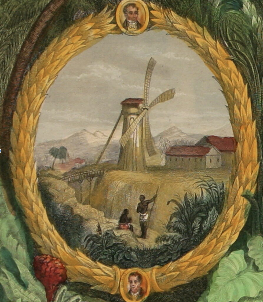
Through its layered symbolism, the left cartouche exemplifies how the map’s embellishments reinforce colonial authority while documenting social and political transformation in post-abolition Guadeloupe (Figure 3). At its center, agricultural labor is depicted against the backdrop of a windmill and plantation buildings, creating a picturesque vision of colonial productivity in a post-abolition setting. One of the largest issues with this depiction of agricultural labor is the representation of Black labor in the foreground. Although this map was created eight years after the abolition of slavery, Levasseur intentionally represents agricultural labor through Black laborers, indicating the difficulties of this transition period after the abolition of slavery. Levasseur’s composition of these figures in this way directly parallels pre-emancipation imagery, reflecting broader Caribbean colonial anxieties about maintaining productivity in the plantations and economies as well as control over newly freed slaves.
The stances of the figures directly suggest their continued status as laborers, rather than a celebration of their newly emancipated status. The comparison from one figure sitting to another standing with his arms open echoes the visual strategies employed in West Indies works to represent an “orderly” transition from slavery to free labor. Similar to Tim Barrigner’s study of Jamaica’s emancipation, this imagery reinforces colonial power dynamics, especially the existing power hierarchies that began long before emancipation.5
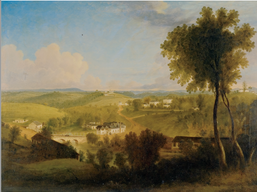
Joseph Bartholomew Kidd’s painting, Good Hope, circa 1835-1836, directly relates to this cartouche (Figure 2). Kidd and Levasseur form a picturesque view of a plantation, developing a falsified sense of beauty and perfection. While this picturesque view is formed, both artists completely disregard the horrors and violence that occurred in these seemingly innocent locations, yet achieve this in different ways. Kidd accomplishes this by obscuring a Black man, who we can assume was a slave, in the shadows of the foreground of the painting. This directly relates to how the transatlantic colonial artistic canon has obscured the horrors of slavery, contributing to the continuation of the colonial power dynamic over slaves even after emancipation. On the other hand, Levasseur accomplishes this same concept by leaving two figures directly in the center and foreground of the cartouche, with a picturesque view of the plantation surrounding them. Yet, this image is a very unlikely representation of what constitutes life post-emancipation in Guadeloupe as a freed slave. This embellishment of post-abolition plantation life hints at the continuity of existing power hierarchies in post-emancipation Guadeloupe.
This idea is further supported by the placement of the windmill, jutting out from the landscape and blocking the view of the mountain range in the background. Moreover, plantation buildings take up much of the right side of the cartouche, extending past the barrier of the frame. This inclusion of the plantation in the background seemingly symbolizes the persistence of the pre-emancipation social hierarchy. In this image, the windmill and plantation buildings seem to act as the eyes of the plantation owners, demonstrating that although these figures seem to be completely alone in this picturesque scene, they are still under the control of the plantation itself. It is this dominance that asserts the colonies’ continued focus on plantation-based agriculture and economy while preserving the existing power structures regardless of the end of slavery.
Levasseur’s inclusion of the portraits of Lethière and Coupenon complicates the meaning of the left cartouche. Guillaume Lethière, a prominent mixed-race artist born in Guadeloupe, was a key abolitionist.9 The portraits of Lethière, and Coupenon, who is likely of the plantation-owning class, create a meaningful juxtaposition that speaks to Guadeloupe’s transformation in social hierarchy. Here, Lethière represents cultural achievement and social mobility within the restrictive colonial system. This pairing with Coupenon creates a deliberate visual commentary on power structures and the transformation of power structures underway at the time. With the laboring figures above Coupenon, it can be inferred that this is a symbolic representation of the alleged triumph of previous slaves over their masters. Yet, the plantation remains in the background of this image as a constant reminder of the pre-emancipation hierarchical status that still exists. It is this placement of figures that creates a sanitized version of post-emancipation colonial relations while simultaneously reinforcing the existing hierarchies, and resisting transition.
Through this cartouche, Levasseur reveals important information about the social transition underway regarding emancipation. This cartouche seemingly serves as a form of propaganda from the French. Levasseur likely added these embellishments to the map to provide context for life in Guadeloupe for those in France interested in creating plantations in Guadeloupe. By depicting Black laborers and developing this continuity in power dynamics of the plantation over its laborers in a post-emancipation society would likely appeal to potential plantation owners thinking about buying land in Guadeloupe. Through the use of the picturesque and portraits surrounding the plantation scene, Levasseur develops an idealized vision of colonial productivity in a post-emancipation society. This directly juxtaposes the tumultuous history of Guadeloupe, which had a very non-constant government and was the site of slave uprisings and constant war between colonial powers. Ultimately, the left cartouche functions as a carefully orchestrated piece of colonial propaganda, utilizing visual elements to assert continued French control over Guadeloupe while managing anxieties about emancipation’s impact on colonial economic and social structures through a picturesque representation of post-emancipation labor relations.
The Right Cartouche
Moving to the right of the map, the right cartouche provides further context into a significant event on the island of Guadeloupe, depicting the earthquake of February 1843 (Figure 4). In the foreground of the cartouche, we see a figure fallen on the ground. Behind the figure, water rushes through the village, with surrounding houses falling in towards the center of the image. Directly in the middle, the ground seems to have opened, with more figures running away from this central point. Similar to the left cartouche, snow-capped mountains loom in the background.
The book “Observations sur le tremblement de terre éprouvé à la Guadeloupe le 8 février 1843” (Observations on the earthquake experienced in Guadeloupe on February 8, 1843) written by Charles Joseph Sainte-Claire Deville provides a witness outlook of this significant event. At the time of this earthquake, Deville was a geologist conducting research in the Western Antilles after completing school at the École des Mines (School of Mines) in Paris. In his book, Deville explains the results of the earthquake, as “Pointe-à-Pitre, this Venice of the Antilles, is now only a heap of rubble” and “part of the population has found death, and each day adds some names to the long list of victims.” 4 Deville later describes the movement of the earthquake as two parts, where buildings were violently shaken horizontally, and then a second vertical shake caused the buildings to fall.4 Deville notes that one person in Pointe-à-Pitre “experienced a sort of rolling; a crowd of people fell, the earth failing them under their feet.” 4
Based on the descriptions provided by Deville, this perfectly lines up with Levasseur’s depiction of the earthquake in Pointe-à-Pitre. Levasseur emphasizes the inward falling of the buildings directly relating to the collapse of Pointe-à-Pitre into rubble. It is plausible that Levasseur may have utilized Deville’s description as a reference for creating this image. Interestingly, no records exist of the number of fatalities or types of people that lost their lives due to this earthquake. This gap in our records of this significant event in Guadeloupean history seems all too convenient, yet reflects the perception of slaves, as well as freed Black people at the time.
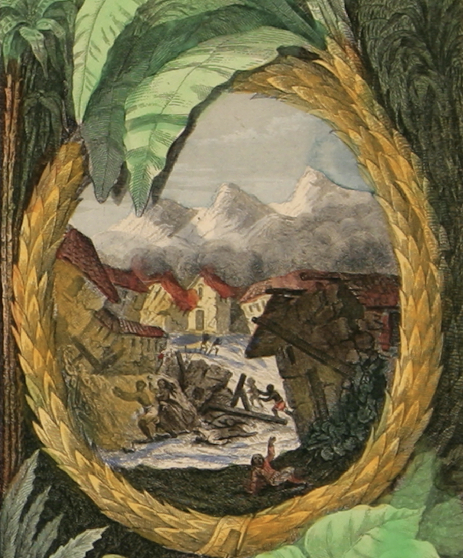
Since this earthquake had a significant impact on Pointe-à-Pitre, the largest harbor city at the time in Guadeloupe, it makes sense that this scene is included in the map as a point of reference for Parisians to understand where Guadeloupe is. Yet, why show a still moment before disaster, instead of showing the aftermath? Thinking with Krista Thompson’s sidelong glance raises many questions about Levasseur’s choice of this specific scene and the figures depicted in it. At the time of this earthquake, slavery was still in practice in Guadeloupe. Yet when this drawing was created, slavery had been abolished for eight years, meaning there must be some intentionality behind Levasseur’s choice of only depicting black figures in this horrifying scene of the earthquake – in which, likely very few of the represented figures survived. Thus, this leads to the question, what was Levasseur’s intention behind this representation of the 1843 earthquake?
Levasseur’s depiction of solely black figures points to the context of slavery at the time of this earthquake. At the moment shown in this image, it is likely that slaves were going about their work, yet like many other representations of slaves at this time, slave owners are nowhere in sight. Meanwhile, the buildings surrounding the figures fall in towards them, towering over them as they try to escape. This portrayal of the earthquake seemingly represents the grasp of slave owners and colonial power. Regardless of the efforts put in to escape slavery, the figures are encapsulated and chained into it – just as the houses collapse, the water hemming in, and the ground opening beneath the figures. Viewing beyond the historical representation of the earthquake, we uncover the important meaning behind the representation reinforcing the broader inescapable nature of colonial power structures.
The right cartouche’s depiction of the 1843 earthquake serves multiple functions beyond mere historical documentation. Levasseur’s choice to represent only Black figures in this scene of devastation, created eight years after abolition, carries significant meaning. This seemingly intentional absence of recorded fatalities among the enslaved population speaks directly to their dehumanization – deaths of the enslaved being treated as loss of property rather than human life. This directly supports the colonial attitude toward slaves at the time, as commodities, not people. Conveniently, it is this continuation of colonial power dynamics that is seen throughout the entire work, with the symbolic nature of the white-capped mountain range following through both cartouches as the highest point. The use of this motif of the mountain range throughout the work particularly coincides with the function of the left cartouche: to calm anxieties of emancipation and the changes in colonial power in Guadeloupe. This further adds complexity to the right cartouche, developing the idea of persistent oversight of colonial authority on the enslaved, and even more so in a newly emancipated society.
The Encapsulating Landscape
One of the most significant features of this work is the landscape that encapsulates the map, both cartouches, and the inscription. This landscape consists of three different parts: the floor of the forest, the forest itself, and the skyline and mountain in the background. The careful arrangement of these elements, particularly the commodities and figures on the forest floor, creates a visual hierarchy that reinforces colonial authority while showcasing Guadeloupe’s economic value and potential for further development.
The floor of the forest contains mostly commodities of the island including sugar, cotton, rubber, tobacco, coffee, cacao, and various fruits. This is directly verified by the primary source from 1843, which explains the main products of Guadeloupe being 36 million kilograms of sugar, 2 million kilograms of cacao, and 400,000 kilograms of cotton.8 By outwardly showing all of these goods in abundance as part of the map, it can be inferred that this functions to demonstrate the economic value of Guadeloupe. In a post-emancipation context, this is extremely important as colonies struggled to maintain economic prosperity after the abolition of slavery. Although Guadeloupe did struggle with the end of slavery, its rapid switch to indentured servitude allowed for the continuity of strength compared to other colonies which struggled a lot more. This can also be viewed under the interpretation that this map was used as French propaganda to lure plantation owners and others from France to develop the island further. By intentionally showing all of these commodities, Levasseur is pointing to the potential of the land, even in a post-emancipation context.

Based on the descriptions provided by Deville, this perfectly lines up with Levasseur’s depiction of the earthquake in Pointe-à-Pitre. Levasseur emphasizes the inward falling of the buildings directly relating to the collapse of Pointe-à-Pitre into rubble. It is plausible that Levasseur may have utilized Deville’s description as a reference for creating this image. Interestingly, no records exist of the number of fatalities or types of people that lost their lives due to this earthquake. This gap in our records of this significant event in Guadeloupean history seems all too convenient, yet reflects the perception of slaves, as well as freed Black people at the time.
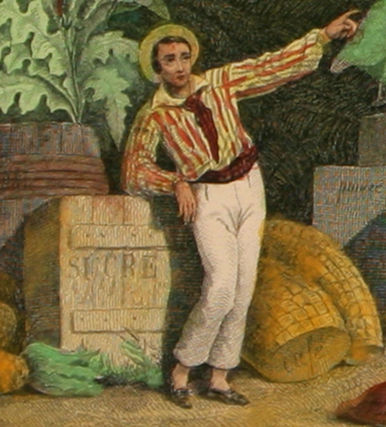
To the left of the map, a white man leaning against a box titled “sucre” (sugar) points toward the map (Figure 6). This is a traditional symbol of colonial power and possession over the area represented in the map.6 Situating the man leaning against the box of sugar develops the outward representation of prosperity and strength of colonial power and plantation owners even after emancipation.
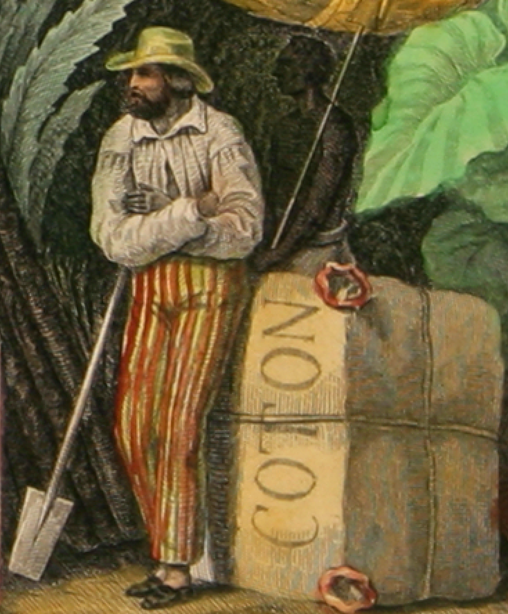
To the right of the map, another white man looks toward the map, with a Black man, who was likely a slave, hidden in the shadows behind him (Figure 7). By including a Black man in this context, Levasseur is directly relaying the fact that even in a post-emancipation society, Guadeloupe’s economy remains reliant on Black laborers. Intentionally, Levasseur places the white figure standing prominently in the foreground next to his commodities – cotton and a Black man. In this case, cotton acts as both an economic symbol and a visual barrier. The invisible here are the harsh realities of slavery that existed to create all of these commodities displayed proudly by the white men in the foreground. In no place is there any representation of the labor, but rather a Europeanized, idealistic version of the strength of Guadeloupe as a colonial power by maintaining pre-abolition power structures.
Interestingly, this motif is continued as we work our way up in the landscape. Next, we view a flourishing tropical forest – a representation of a common landscape seen in Guadeloupe (Figure 8). Levasseur creates a seamless transition between the forest floor and the forest itself by including plants in the background that extend up towards the thick of the forest. This continuity from forest floor to forest looks as though the plants are flourishing out of the commodities. By creating this representation, Levasseur seems to suggest the idea that Guadeloupe continues to flourish, like this tropical forest, even after the abolition of slavery. Beyond this, this expansive forest symbolizes the potential for more plantations, signaling to those who have not explored the island that there is still land to be tamed and room for economic growth. By demonstrating this potential for economic growth, Levasseur is expanding on the main purpose of this work: to calm colonial post-abolition anxieties with the transition out of slavery.
The skyline part of the landscape adds further complexity to the overall work by employing the mountain symbol (Figure 9). By positioning the mountain as the pinnacle of this work, the mountain serves as another reminder of colonial power dynamics that remain constant even in a post-emancipation society. This continuous motif throughout the cartouches and the entire work reinforces French colonial authority through visual hierarchy – the white-capped peaks literally and figuratively oversee all activity below, from the agricultural scenes to the commodities on display.

The landscape’s three-tiered structure – from the commodity-laden floor through flourishing forest to commanding mountain peaks – creates a carefully orchestrated visual narrative about colonial control and economic potential. Each level serves to reassure the predominantly French audience about Guadeloupe’s continued productivity and opportunities for development, while simultaneously reinforcing existing pre-emancipation power structures. Through this intricate arrangement of natural and commercial elements, Levasseur transforms what might appear as mere decorative embellishment into a sophisticated piece of colonial propaganda. This is then utilized to promote continued French investment in post-abolition Guadeloupe. This interpretation of the landscape elements reveals how the map functions beyond mere cartographic documentation, instead working as a complex visual argument for continued colonial presence and work to maintain the pre-abolition economic development.
Conclusion
Through careful analysis of the 1856 print map of Guadeloupe with hand coloring Colonies Françaises (en Amérique) from Atlas National Illustrè, we uncover a sophisticated piece of colonial propaganda that worked to maintain French control over Guadeloupe during a pivotal transition period from slavery. The cartouches, landscape elements, and figure placement all contribute to a carefully constructed narrative about colonial power and economic potential in post-abolition Guadeloupe. The map’s embellishments serve multiple purposes. Most importantly, the embellishments help form an idealized version of post-abolition Guadeloupe to reassure French audiences about continued productivity, calming anxieties about emancipation’s impact on colonial power dynamics and hierarchy. Through these embellishments Levasseur accomplishes a sanitized representation of the realities of post-emancipation labor relations – portraying a productive Guadeloupe without slavery, yet one that is still heavily reliant on Black labor. It becomes this idealization that forces us to question the validity of the representations in this image, one that is laden with misleading information about the current state of affairs in Guadeloupe at this time.
Due to the nature and context of this map, we must alter our approach to French West Indies representations in this period. Viewing these works for their aesthetics, we completely disregard an important part of the story that all too frequently goes unheard and unrecorded: the post-emancipation lives of freed slaves in the French West Indies. Although little documentation exists on this subject matter in the French West Indies, this provides further reasoning to approach these types of representations with skepticism of the validity of the representations – utilizing Krista Thompson’s sidelong glance to understand the intention behind the visible and uncover the invisible aspects of these representations. Future research should apply this methodology and thinking to gain further insight into French West Indies representations, especially those existing within the complex post-emancipation colonial society.
References
- Pluskota, Marion. “Freedom of Movement, Access to the Urban Centres, and Abolition of Slavery in the French Caribbean.” International Review of Social History 65, no. S28 (2020): 93–115. https://doi.org/10.1017/S0020859020000103.
- United States of America Department of State Office of the Historian. n.d. “Milestones in the History of U.S. Foreign Relations – Office of the Historian.” United States Office of the Historian. Accessed December 1, 2024. https://history.state.gov/milestones/1750-1775/treaty-of-paris.
- “Monument to Abolition of Slavery | Slavery and Remembrance.” 2024. United Nations Educational, Scientific, and Cultural Organization. 2024. Accessed December 1, 2024. https://slaveryandremembrance.org/partners/partner/?id=P0054#:~:text=February%204%2C%201794%3A%20The%20First%20Abolition&text=Meanwhile%20in%20Guadeloupe%2C%20the%20English,proclaimed%20on%20June%207th%2C%201794.
- Deville, Charles. 1845. TREMBLEMENT DE TERRE EPROUVE a LA GUADELOUPE LE 8 FEVRIER 1845. PDF of print. 1st ed. IMPRIMERIE DU GOUVERNEMENT. https://ia600306.us.archive.org/35/items/bub_gb_I740WrjzVUwC/bub_gb_I740WrjzVUwC.pdf.
- BARRINGER, TIM. “Land, Labor, Landscape: Views of the Plantation in Victorian Jamaica.” In Victorian Jamaica, edited by TIM BARRINGER and WAYNE MODEST, 281–321. Duke University Press, 2018. https://doi.org/10.2307/j.ctv11hpgxv.36.
- Dodds, Klaus. “Gesture and Posture: Pointing the Finger and the Mapping of Outer Continental Shelves.” Polar Record 46, no. 3 (2010): 282–84. https://doi.org/10.1017/S0032247409990519.
- Thompson, Krista. 2011. “A Sidelong Glance: The Practice of African Diaspora Art History in the United States.” Art Journal 70 (3): 6–31. doi:10.1080/00043249.2011.10791045.
- Martin de Villers, Juan Pedro. Estadística y topografía de la isla la Guadalupe y dependencias. Habana: Imprenta del Gobierno y Capitanía general por S. M., 1843. Book. Burke Library at Hamilton College, Clinton, NY. The Beinecke Lesser Antilles Collection of Hamilton College
- Lafont, Anne. “Art and Politics: Revolutions in Pigment (1770-1830)” in Guillaume Lethière, (New Haven and London: Yale University Press, 2024), 97-107.