By the mid-19th century, French Caribbean society had devolved into turmoil. The former French Antilles had drastically transformed from a thriving, new-world agricultural economy, representing France’s imperial might in the Caribbean, to an emancipated, emerging society. Following the slave revolutions of 1848, slavery, which was reinstated during the reign of Napoleon I, was again abolished for a final time. Agricultural and mercantilist trade from sought-after colonial goods was no longer sourced from a codified system of unpaid labor but rather a result of a new relationship between sharecropping freed people and the Caribbean elite. In addition, a long history of inter-European conflict resulted in an unstable and shifting ownership of the Caribbean islands.
This background points to a destabilized France, whose colonial identity and presence had significantly decreased by the mid-19th century. The cross-cultural feedback from these historical events influenced French artistic consciousness which in turn altered artistic representations of the Caribbean colonies. Tim Barringer explores these changes in his essay,“Land, Labor, Landscape: Views of the Plantation in Victorian Jamaica in Victorian Jamaica.” Barringer explains that the colonial artistic scene had long been dominated by oil paintings and lithography during the early 19th century. However, by the mid-19th century, colonial representation shifted towards photography and wood engravings. This occured due to the availability of new technology that could appeal to a broader audience. While Barringer explores this change in the art coming from the British West Indies, this manifestation occurs in a similar fashion in the French colonies. Both experienced deviations from traditional landscape painting, which raise questions about those contemporary artist’s motivation and intended audience. Unlike Britain, France experienced a greater identity crisis regarding its colonial holdings. Thus it begs the question, did these new engravings serve to educate and appeal to the French public? Or was the context for popularizing colonial representation bolstered by a paternalistic desire to reaffirm control of the French colonies?
This departure from artistic tradition became a significant problem for French artists who sought to promote an imperially weakened France. A manifestation of this desire to regain colonial supremacy was through a new artisitc interpretation of cadastral maps.Traditionally, cadastral maps were used as a formal grouping that detailed the ownership, location, and value of a given land. The use of these maps generally served to organize complex legal zoning, boundaries, and ownership of land parcels. While this pragmatic tool would not normally function outside a legal setting, French artists were able to adopt this tradition and transform it into a means of creating an overview of French colonial holdings. In “Understanding Cadastral Maps,” by Ian Phillip Williamson and Stig Enemark, the authors explain that the success of cadastral maps is determined by how well they achieve “broad social and economic objectives,” not by the complexity of their legal framework. This explanation supports my claim that colonial maps can be viewed as a part of a cadastral tradition as it, most importantly, works as colonial propaganda for its readership; this new artistic motif became a transatlantic canon fueled by a desire for France to reaffirm its ownership of the Antilles amidst growing imperialist discord.
I am using Colonies Françaises (en Amérique) by Victor Levasseur as a case study to navigate these problems. Victor Levasseur was a cartographer born on the 8th of December in 1800 in the Normandie commune of Caen. He was most known for his primary cadastral and encyclopedic manuscript, L’Atlas National Illustré des 86 départements et des possessions de la France (The National Illustrated Atlas of the 86 Departments and Possession of France) of 1856. This book included detailed maps of various French possessions, with relevant illustrations and supplementary texts tailored for a French audience. This included information such as population demographics, local fauna and flora, and a territory’s importance from a historical and economic standpoint. Within the context of colonial representation, the existence of this map and others like it represents a microcosm of colonial dynamics.
To best frame these relationships, I will use concepts from Mary Louise Pratts’ Imperial Eyes, where she endeavors to dissect the imperalistic mentalities of European metropolitan readership. The historiographic and sociological terms described in Imperial Eyes are useful for explaining the complex relationship between this readership and the French colonialist mentality that dominated the 19th century. The main term I will focus on is Anti-conquest, which is crucial in understanding the motive behind the cadastral representation of colonial lands. Anti-conquest occurs when colonial representation is used as a tool by European bourgeoisie to secure European innocence and at the same time European hegemony. However, I will expand Pratts’ analysis by focusing on how Anti-conquest representation is supported by paternalistic rationalizations. In this essay I argue that Levasseur’s inclusion of the surrounding illustrations works as a means of re-establishing French hegemony in the French Antilles; it is through this cadastral map that Levasseur appeals to a metropolitan French audience during a period when France was uncertain about its own colonial influence.
Dissection of engraving
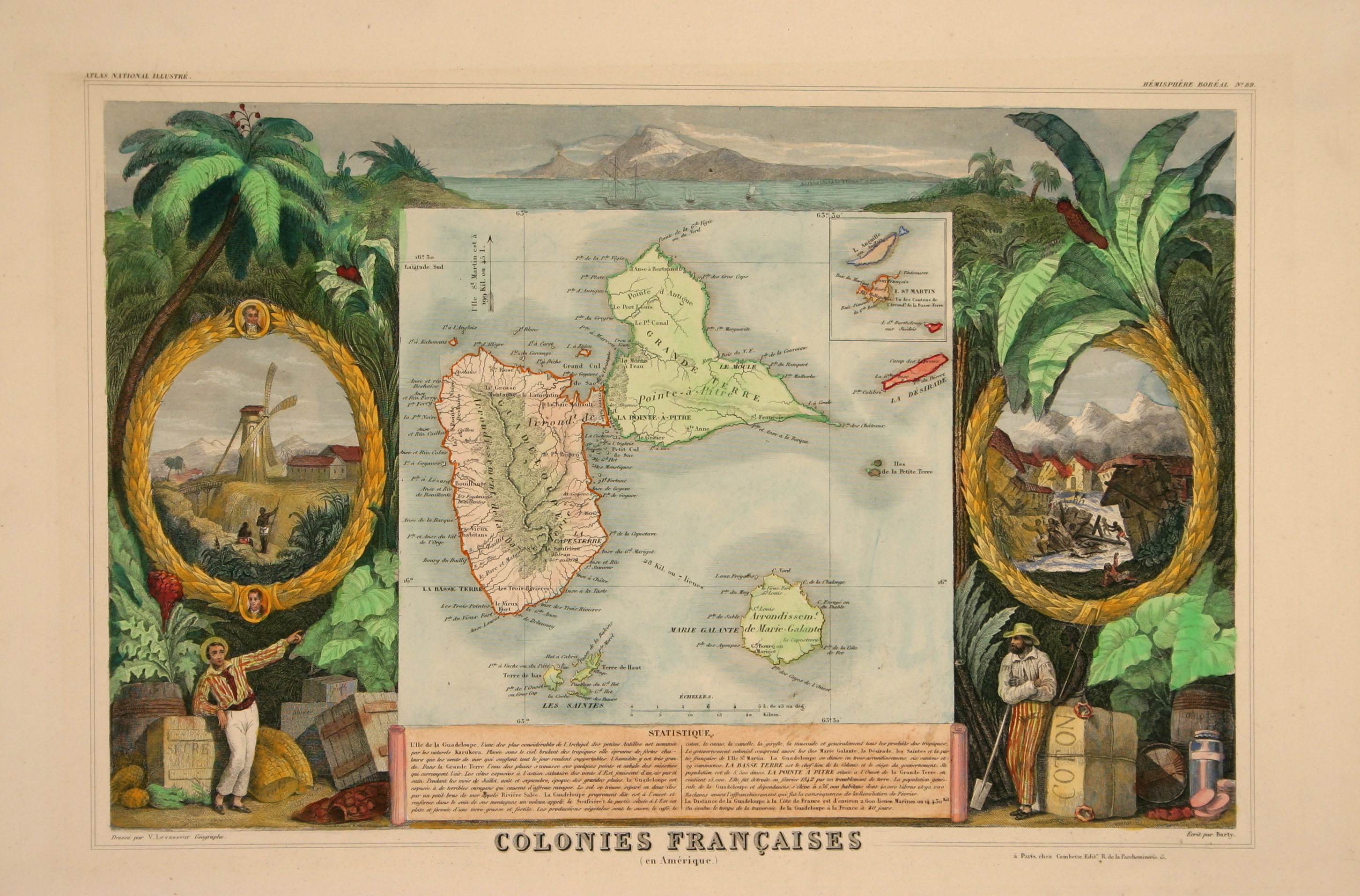
Victor Levasseur, Colonies Françaises (en Amérique), Engraving with hand coloring, c.1856, Composition: 26.4 × 41 cm, The Beinecke Lesser Antilles Collection of Hamilton College, http://emuseum-2022.hamilton.edu/objects/792/colonies-francaises-en-amerique-the-french-colonies-in-am?ctx=b9e8eb9ffad5c1da22a291b2781806881ab03505&idx=10
Now that we have a historiographic background of the political and artisic climate of the mid-19th century Antilles, we can begin dissecting the components of the engraving.
The central focus of the engraving is the map. Levasseur presents a comprehensive overview of the French colonial holdings of the Antilles, including most importantly the island of Guadaloupe. While this map may not seem strikingly different from other contemporary maps, its unique cadastral components elucidate the identity of its readership.
In considering the readership of L’Atlas Nationale Illustré, we turn to the terminology employed to organize the islands. Levasseur uses the term “arrondissement,” which was a system used to subdivide Paris. This was introduced as a classification of the Antilles in the mid-19th century, a little after Paris itself was organized into arrondissements around the beginning of the 19th century. This would have appealed to the French metropolitan audience who were familiar with this system. As previously mentioned, the Antilles were historically contested imperial territories, and thus, it would make sense for contemporary artists to want to incorporate the colonial Antilles as a unified part of the French empire. The readers were likely familiar with this system of administrative districts and affluent enough to purchase L’Atlas Nationale Illustré and participate actively within Paris’ metropolitan setting.

Victor Levasseur, Colonies Françaises (en Amérique), Engraving with hand coloring, c.1856, Composition: 26.4 × 41 cm, The Beinecke Lesser Antilles Collection of Hamilton College, http://emuseum-2022.hamilton.edu/objects/792/colonies-francaises-en-amerique-the-french-colonies-in-am?ctx=b9e8eb9ffad5c1da22a291b2781806881ab03505&idx=10
Map and “Statistique” Box
The next portion of the engraving featured a small paragraph detailing statistical and demographic information about the featured islands. It was written by French art critic, Phillipe Burty (1830-1890) and to understand its purpose, it is important to understand Burty’s relationship to the artistic sphere. As outlined in Ségolène Le Men’s essay, “Metaphor for Translation: Philippe Burty and the Gazette des Beaux-Arts in the Second Empire,” Burty was considered one of the first art critics who saw the importance of print and engraving art forms. Le Men argues that Burty believed that such art served as a “go-between” that crossed the boundaries between the arts and the public. Ségolène explains that Burty believed in the concept of “translation” where, unlike photography, maps required an interpretative translation which could be explained by the art critic. With this information, we can understand Burty’s role as the “translator” of the Statistique text.
Burty deviates from the expected traditions of cadastral commentary by incorporating poetically described information about the Lesser Antilles environment. Burty begins the text by referencing the native name for Guadeloupe, Karukera. This included detail extends beyond what would be expected from cadastral map commentary. This fact seems more likely to be found within a text that is motivated to inform a curious reader who would intellectually inquire about the origin of the featured lands. Burty properly “translates” what he believes the audience would be interested in, thus informing us about the perceived readership.
It next describes the climate with surprising sensorial descriptions such as the “blazing tropical sun […] strong heat […] sea breezes that blow throughout the day making it bearable […].” These details seem out of place if this was purely a cadastral map. However, the surrounding artworks contextualize Burty’s tone. In a way, Burty, who is the author of the text, intentionally embellishes this detail to appeal to his readers. By including these flourishes, Burty portrays these French holdings as a nice tropical setting, which entices curious readers.
Burty describes the Eastern part of Guadeloupe as an ideal place to live and cultivate tropical crops, an appeal to impressionable French metropolitan readers. Burty continues by describing the high humidity and potential dangers of water-based miasma, that contaminates the air. This speaks to the tradition of portraying the Tropics as uniquely diseased riddled. An informed and curious audience of the Tropics would appreciate this inclusion, likely familiar with the miasma mentioned. To combat this threat of disease, Burty points to the eastern coasts as ripe with “winds [that] enjoy pure and healthy air.” Coincidentally, those same eastern parts are flat and made up of rich fertile soil that is used to cultivate and produce commodities such as sugar, coffee, cotton, cocoa, cinnamon, cloves, nutmeg, and “generally all the products of the tropics.” In context to the surrounding illustrations, this line is one of the most pertinent. The importance of Caribbean commodities from a cadastral perspective is great, as the potential resources cultivated from those territories define their values. That is why Levasseur portrays the agricultural lands as a haven amongst the dangerous tropics.
The Lower Tier Illustrations


Victor Levasseur, Colonies Françaises (en Amérique), Engraving with hand coloring, c.1856, Composition: 26.4 × 41 cm, The Beinecke Lesser Antilles Collection of Hamilton College, http://emuseum-2022.hamilton.edu/objects/792/colonies-francaises-en-amerique-the-french-colonies-in-am?ctx=b9e8eb9ffad5c1da22a291b2781806881ab03505&idx=10
The lowest tier of the engraving appeals most to its readers by portraying the Eastern coasts’ exotic climate and fertile lands as within French control. This is achieved through the artist’s composition and positioning of the three men relative to the surrounding elements. Two men, white Europeans, are in the foreground and are dressed in colorful summertime European clothing. The man on the left looks at the reader while pointing to the map. The second European man stands cross-armed, facing the Statistique box. This composition indirectly informs the readers about the most relevant elements of the engraving. Around them lies the Caribbean goods mentioned in the Statistique box, that make their way into European markets through transatlantic trade. Interestingly, we see a third figure, obscured in the background, standing next to the man on the right. He is Black and clothed only at his waist, holding a spear. By placing him in the background amongst the various strewn-about bundles of commodities. Levasseur indirectly commodifies this man. Even though slavery had since been abolished, the illustrator reaffirms that France retains its colonial power over the local population. By portraying this man with rustic clothing and tools, we see the concept of Anti-conquest in effect, where the “innocent” White Europeans oversee previously enslaved people by incorporated them within French hegemony.
Golden Wreaths


Victor Levasseur, Colonies Françaises (en Amérique), Engraving with hand coloring, c.1856, Composition: 26.4 × 41 cm, The Beinecke Lesser Antilles Collection of Hamilton College, http://emuseum-2022.hamilton.edu/objects/792/colonies-francaises-en-amerique-the-french-colonies-in-am?ctx=b9e8eb9ffad5c1da22a291b2781806881ab03505&idx=10
This concept of recurring rustic representation of the colonial Black population returns within the left golden wreath. Here, we see the rustic Black population in similar dress. Compositionally, they stand lower in the hierarchy than the central focus of this wreath illustration: the windmill. This building represents the processing of Caribbean goods. The subsumed positioning of the small Black figures compared to the mill harkens to themes of Black representation within Cécile Fromont’s essay, “Penned by Encounter: Visibility and Invisibility of the Cross-Cultural in Images from Early Modern Franciscan Missions in Central Africa and Central Mexico.” Fromont explores idyllic landscapes and how Black figures lose their individuality in “picturesque” prints. In a similar composition to Fromont’s explored etchings, the map’s Black figures are placed in the lowest tier of the brooch’s engraving. They appear like ants in a larger natural setting, now tamed by the machine of agriculture. This compositional subjugation speaks to the artist’s intent to disparage the local Black population. Even though slavery had been abolished in the colonies, Levasseur attempted to appeal to a French population uncertain about colonial dynamics between European settlers and the newly emancipated population. The idea of the Anti-conquest returns as by exercising colonial superiority over a group, France appeared as a rightful paternalistic overseer.
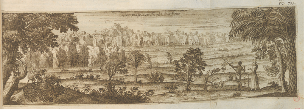
Paolo da Lorena (attr.). Pungu a Ndongo or Fortress of the Pedras Negras, from Giovanni Antonio Cavazzi and Fortunato Alamandini, Istorica descrizione de’ tre’ regni Congo, Matamba, et Angola, 1687
In appealing to the French intellectual audience, we see portraits of two figures on that wreath: Guillaume Guillon-Lethière and Coupenon. While the identity of Coupenon is unknown, Lethière was a notable biracial artist born in Guadeloupe. We can likely infer that Coupenon would have been a similarly recognizable name to the contemporary readership of the Altas National. This serves as another way to relate to an educated audience by referencing notable individuals who potentially emerged from the Antilles.
The second wreath illustration is initially presented in the Statistique box as the Pointe-à-Pitre Earthquake of 1843. Compared to the left wreath, we see the right wreath wrap around the image, a part of the tropical tree’s trunk. This composition represents the local nature constricting the scene, similar to how the earthquake of 1843 proved the local population was still powerless against the dangerous, tropical environment. Unlike the left wreath, which shows agricultural infrastructure, symbolized through the presiding windmill, the housing infrastructure is devastated by floods. In the Stastique box, Burty informs readers about the “terrible hurricanes that cause awful destruction.” In Levasseur’s depiction, we see that the figures portrayed suffering from the flooding are all a part of the island’s Black population. In continuity with the other wreath’s portrayal of the colonies’ Black population, they are sparsely clothed except for the man lying down at the bottom of the illustration.
However, when taking into account the true population of Guadeloupe at the time, this misrepresentation of the population demographics complicates Levasseur’s portrayal of the flooding’s victims. The bottom box states that out of the 136,00 total inhabitants of the French colonies, “40,000 [were] Free and 90,000 [were] Slaves before the emancipation which was the consequence of the February Revolution.” Levasseur mentions the demographics of the inhabitants of the colonies and their emancipation status pre- and post-revolution. By referencing the prior enslaved status of the colonies’ populations, in tandem with the disparaging imagery of a rustic Black population, Levasseur indirectly reaffirms the imperial status of France over its colonial subjects. Importantly, this information does inform us that there was still a significant white population grossly represented by the “40,000 [Free].”

Victor Levasseur, Colonies Françaises (en Amérique), Engraving with hand coloring, c.1856, Composition: 26.4 × 41 cm, The Beinecke Lesser Antilles Collection of Hamilton College, http://emuseum-2022.hamilton.edu/objects/792/colonies-francaises-en-amerique-the-french-colonies-in-am?ctx=b9e8eb9ffad5c1da22a291b2781806881ab03505&idx=10
The general disparity in representation between the White Europeans and the Black population within this map harkens to the traditions of imperialist paternalism. By making solely the Black population the represented victim of the earthquake, Levasseur establishes again the Anti-conquest, where the innocent Europeans must take care of a victimized, inferior population by establishing European dominance. What further complicates this biased rendering is an account of the earthquake by a British author: The Earthquake of Antigua: February 8th, 1843. In this text, the author omits any reference to race and social status in its descriptions of the victims. Instead, these descriptions lend a degree of volition and dignity to the inhabitants, stating that “Many on that beautiful morn […] left […] to engage in the diligence of their respective vocations.” These “vocations” are later expanded upon, with the author referencing the job of “the merchant, the mariner, agriculturalist, the mechanic, the pedlar, and the laborer […] were happy with the prospect of success and reward.” This English perspective is less concerned with the identity of the victims but rather with their work. This complicates Levasseur’s illustrations; if the population affected was truly majority Black, and if by the written account they were employed and integrated within society, why would Levasseur depict them as rustic and existing apart from the society’s norms? The written account paints a different picture, one of a cohesive society where all suffered, both White and Black, from the earthquake’s devastation.
Highest Tier and Concluding Discussion

Victor Levasseur, Colonies Françaises (en Amérique), Engraving with hand coloring, c.1856, Composition: 26.4 × 41 cm, The Beinecke Lesser Antilles Collection of Hamilton College, http://emuseum-2022.hamilton.edu/objects/792/colonies-francaises-en-amerique-the-french-colonies-in-am?ctx=b9e8eb9ffad5c1da22a291b2781806881ab03505&idx=10
The highest tier represents the full circle of transatlantic connections, symbolized through the ships. The Statistique box concludes by relating the distance between France and its colonies, “the distance from Guadeloupe to the coast of France is around 2,600 nautical miles or 14,430 kilometers. The time to cross from Guadeloupe to France is an estimated 40 days.” This relational description reinforces the colonial dynamic of ownership described within the cadastral map. Ships are the foundational tool used for colonialism as they bound the indigenous and former slave populations to the mercantilist demands of Europe. Colonialism represented for the first time the dominance over people of distinctly different origins whose lands were fertile and rife with novel goods. It was the greed of Europe and France that rationalized slavery and the inhuman treatment of non-Europeans; thus emerged a codified transatlantic trade network. This map embodies this greed and a desire to maintain colonial power. By compositionally creating an ordered setting, Levasseur attempts to portray French colonial governance as cohesive and secure which has been unchanged since the beginning of colonial expansion. Yet, this was no longer the case. Europe failed to reconcile its wounded pride as the shifting ideological and historical movements of the 19th century irreversible changed colonial dynamics. The portrayal of the Black population as rustic and safeguarded by European paternalism was no longer possible since globalized communication and interaction of that same Black population with European culture gave birth to a new transatlantic culture. And with the abolition of slavery, that European ideal began to diminish.
References:
“Colonies Françaises (En Amérique) (the French Colonies in America), from Atlas National Illustrè (Illustrated National Atlas).” eMuseum, January 1, 1970. http://emuseum-2022.hamilton.edu/objects/792/colonies-francaises-en-amerique-the-french-colonies-in-am?ctx=b9e8eb9ffad5c1da22a291b2781806881ab03505&idx=10.
Barringer, Tim. “Land, Labor, Landscape.” Victorian Jamaica, 2018, 281–321. https://doi.org/10.1215/9780822374626-010.
Williamson, Ian, and Stig Enemark. “Understanding Cadastral Maps.” Australian Surveyor 41, no. 1 (March 1996): 38–52. https://doi.org/10.1080/00050336.1996.10558593.
“BNF Catalogue Général.” Catalogue Général. Accessed December 17, 2024. https://catalogue.bnf.fr/ark:/12148/cb15369550q.
Pratt, Mary Louise. Imperial Eyes. London: Routledge, 1992.
Le Men, Ségolène. “Printmaking as Metaphor for Translation: Philippe Burty and the Gazette des Beaux-Arts in the Second Empire”, Art Criticism and its Institutions, dir. Michael Orwicz, Manchester University Press, 1994, pp. 88-108.
Fromont, Cécile. Penned by encounter: Visibility and invisibility of the cross-cultural in images from early modern Franciscan missions in Central Africa and Central Mexico, 2022.
The Earthquake at Antigua : February 8, 1843. Printed at the Columbian Press Office, 1843.
Images:
Victor Levasseur, Colonies Françaises (en Amérique), Engraving with hand coloring, c.1856, Composition: 26.4 × 41 cm, The Beinecke Lesser Antilles Collection of Hamilton College, http://emuseum-2022.hamilton.edu/objects/792/colonies-francaises-en-amerique-the-french-colonies-in-am?ctx=b9e8eb9ffad5c1da22a291b2781806881ab03505&idx=10
Paolo da Lorena (attr.). Pungu a Ndongo or Fortress of the Pedras Negras, from Giovanni Antonio Cavazzi and Fortunato Alamandini, Istorica descrizione de’ tre’ regni Congo, Matamba, et Angola, 1687.
Leave a Reply